The Civil Side: Survey, Field to Finish
Previous versions of Land Development Desktop and AutoCAD Civil 3D have used Fieldbook (.fbk) files in order to process linework that was collected by surveyors in the field. In order to collect linework out in the field using prior versions of Autodesk's civil software, you need to add a "note" into your data collector with a code from the synonym file allowing the points with the same description to have 3D linework or "figures" connecting them. These notes were stored in the .raw or .rw5 data file; you then convert the raw data file into a fieldbook file and import this into the program. Some data collectors can convert these files automatically, other times you need to download the raw file and use AutoCAD Civil 3D or a free applet (such as Carlson Connect, Leica Exchange or Trimble Link) for the conversion.
This process makes for ease of post processing survey data and topo breakdown. It also aids in surface creation because the figures that are drawn in the field can be imported into AutoCAD Civil 3D and used to quickly create a topographic surface model of the existing conditions.
Changes in AutoCAD Civil 3D 2010 Auto Linework
I am extremely excited to discuss the changes and advances to the survey linework processing capabilities within the latest release of the software. You can now put the days of using .raw and .rw5 files converted into .fbk files behind you. AutoCAD Civil 3D 2010 now uses double, triple, and even quadruple point coding within ASCII files to process and draw linework. How can you do this, you ask? Read on for a brief "How-to"!
Start by initiating your survey toolspace; within this area there is a new style named Linework Code Sets, as shown below.
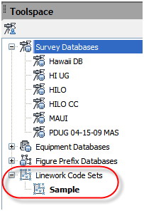
The Linework Code Sets within the Survey tools of AutoCAD Civil 3D 2010 allow you to set up linework codes that are alpha or numeric, depending on your needs. The first step is to right-click on Linework Code Sets --> New, then give your code set a name based on your company's standards. Now you can edit your code set to match what was shot and coded out in the field.
In the example that I will use, the points were coded numerically so I have changed the default fields of Special Codes-Begin to a numeric value of 1 (the default comes with B) and the Special Codes-End to a numeric value of 5 (the default comes with E), as shown below.

Next, I will give a preview of the ASCII file that I am going to import. This file, shown below, is PNEZD comma delimited, double coded.
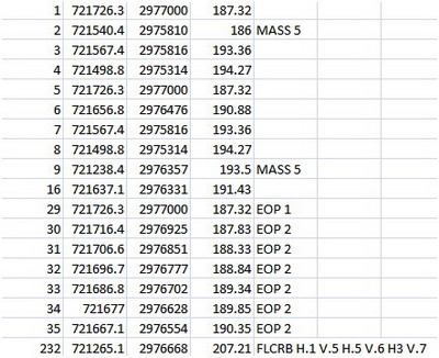
As you can see from the capture above, the points have been double coded and the last point, #232, has six codes in order to draw out the curb line. Multiple point coding has finally arrived!
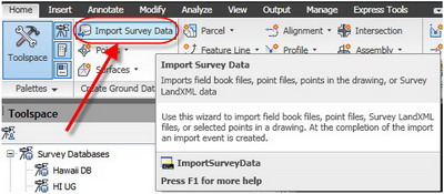
After you set up your linework code set, it is now time to create a new survey database and import in your ASCII file. From the "Home" tab on your ribbon, select Import Survey Data, as shown below.
This launches a wizard that will walk you through the process of creating a new survey database for your project, a new network, selecting your code file, and importing your linework.
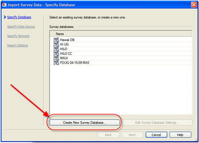
You need to give your survey database a name (it may be best to name the database the same as your project name). After you create your survey database you can then Edit Survey Database Settings to add in your state plane coordinate zone, then select next, as shown below.
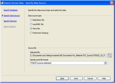
You can now specify the types of data that you wish to bring in to your newly created survey database. Your choices are .fbk, LandXML, ASCII file, or points that may have already been imported into your current drawing that you wish to move into the database.
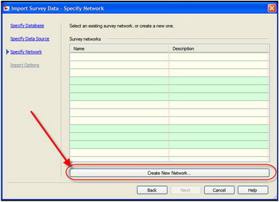
You can now create a New Network with the data that you will be importing for today's TOPO. Keep in mind when creating multiple networks for the same survey database that you CANNOT run Traverse and Least Squares Analysis across multiple networks. This will help you to determine when you will need to create a new network and when you should add data to an existing network.
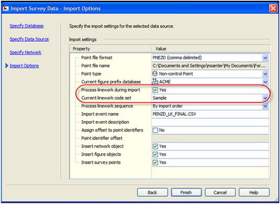
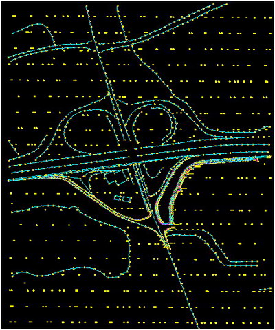
Last but not least, you want to make sure as you are going to process your linework that you are using the correct code set and figure prefix database. The final product from importing the coded ASCII file is shown below.
Being able to collect points and linework in the field and process that data in AutoCAD Civil 3D 2010 just became a breeze. Fieldbook files are no longer the only way to bring auto linework data into Civil 3D. Hip, hip, hooray!